

You are hereFlight Planning / Aerial tours / Patton's Desert Training Center Aerial Tour
Patton's Desert Training Center Aerial Tour
GPS Waypoints
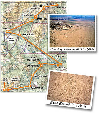
An aerial tour of the WWII Desert Training Center, General Patton's complex of camps and bases used to train troops for combat in North Africa, is presented in our Winter 2001/2002 issue. This tour is expected to become an official sky trail, with supplemental material published by the California Bureau of Land Management (BLM), in early 2002. Please read the article on page 42 of the Winter issue for more details on flying the Sky Trail.
GPS waypoints make your navigation a lot easier. You can download the waypoints as a text file, or you can enter them manually from the table below.
Download GPS waypoints:
The route in Tab Delimited Text format and the Readme text file.
(Note: Clicking on the above links will bring up the text document automatically. Windows users can right-mouse-click on the links and select "Save Target As" or"Save Link As" to download the file. Macintosh users can click and hold until another menu pops up, giving you the option to download.)
The Waypoints and Coordinates:
If you cannot upload coordinates into your GPS and need to do so manually, the waypoints are listed below:
|
ID |
Name |
LatD |
LatM |
N/S |
LonD |
LonM |
E/W |
|
2CYNG |
Camp Young |
33 |
40.4 |
N |
115 |
47.0 |
W |
|
L77 |
Chiriaco Summit |
33 |
39.9 |
N |
115 |
42.6 |
W |
|
L64 |
Desert Center |
33 |
44.9 |
N |
115 |
19.4 |
W |
|
2CCXM |
Camp Coxcomb |
33 |
54.7 |
N |
115 |
16.4 |
W |
|
2CGRN |
Camp Granite |
34 |
3.3 |
N |
115 |
6.9 |
W |
|
2CIMT |
Camp Iron Mountain |
34 |
6.0 |
N |
115 |
9.5 |
W |
|
2RICE |
Rice Field |
34 |
3.7 |
N |
114 |
48.9 |
W |
|
2CRCE |
Camp Rice |
34 |
4.6 |
N |
114 |
45.7 |
W |
|
2CDZD |
Cadiz Dunes |
34 |
21.5 |
N |
115 |
23.5 |
W |
|
2CDZS |
Cadiz Siding |
34 |
31.2 |
N |
115 |
30.5 |
W |
|
2AMBY |
Amboy and Roy's |
34 |
33.6 |
N |
115 |
44.7 |
W |
|
2AMBC |
Amboy Crater |
34 |
32.7 |
N |
115 |
47.4 |
W |
|
2CCLP |
Camp Clipper |
34 |
44.0 |
N |
115 |
17.0 |
W |
|
2ESX |
Essex Field |
34 |
46.3 |
N |
115 |
13.2 |
W |
|
2CESX |
Camp Essex |
34 |
47.9 |
N |
115 |
13.5 |
W |
|
2CGFS |
Camp Goffs |
34 |
55.1 |
N |
115 |
4.2 |
W |
|
2GOFS |
Goffs Field |
34 |
56.2 |
N |
115 |
4.1 |
W |
|
2IBIS |
Ibis Field |
34 |
58.4 |
N |
114 |
50.4 |
W |
|
2CIBS |
Camp Ibis |
34 |
58.2 |
N |
114 |
49.4 |
W |
Meanings of columns in the above table:
ID: Three- to five-character waypoint ID.
Name: Name of the waypoint.
LatD: Whole degrees of latitude of the waypoint.
LatM: Minutes and tenths of minutes of latitude of the waypoint (e.g. "42.3").
N/S: Always "N" to signify north latitude (required by some GPS programs).
LonD: Whole degrees of longitude of the waypoint.
LonM: Minutes and tenths of minutes of longitude of the waypoint (e.g. "25.3").
E/W: Always "W" to signify west longitude (required by some GPS programs).